


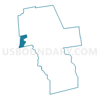
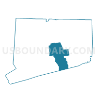
Durham 3 Voting District, Middlesex County, Connecticut
About
Outline

Summary
| Unique Area Identifier | 549876 |
| Name | Durham 3 Voting District |
| County | Middlesex County |
| State | Connecticut |
| Area (square miles) | 7.57 |
| Land Area (square miles) | 7.48 |
| Water Area (square miles) | 0.09 |
| % of Land Area | 98.83 |
| % of Water Area | 1.17 |
| Latitude of the Internal Point | 41.45872760 |
| Longtitude of the Internal Point | -72.72903750 |
Maps

Graphs
Select a template below for downloading or customizing gragh for Durham 3 Voting District, Middlesex County, Connecticut


Neighbors
Neighoring Voting District (by Name) Neighboring Voting District on the Map
- Durham 2 Voting District, Middlesex County, CT
- Guilford 4 Voting District, New Haven County, CT
- Middlefield 1 Voting District, Middlesex County, CT
- North Branford 2 Voting District, New Haven County, CT
- Wallingford 1 Voting District, New Haven County, CT
- Wallingford 9 Voting District, New Haven County, CT
Top 10 Neighboring County Subdivision (by Population) Neighboring County Subdivision on the Map
- Wallingford town, New Haven County, CT (45,135)
- Guilford town, New Haven County, CT (22,375)
- North Branford town, New Haven County, CT (14,407)
- Durham town, Middlesex County, CT (7,388)
- Middlefield town, Middlesex County, CT (4,425)
Top 10 Neighboring Place (by Population) Neighboring Place on the Map
Top 10 Neighboring Unified School District (by Population) Neighboring Unified School District on the Map
- Wallingford School District, CT (45,135)
- Guilford School District, CT (22,375)
- North Branford School District, CT (14,407)
- Regional School District 13, CT (11,813)
Top 10 Neighboring State Legislative District Lower Chamber (by Population) Neighboring State Legislative District Lower Chamber on the Map
- State House District 100, CT (23,554)
- State House District 101, CT (23,252)
- State House District 90, CT (22,544)
- State House District 86, CT (21,996)
Top 10 Neighboring State Legislative District Upper Chamber (by Population) Neighboring State Legislative District Upper Chamber on the Map
- State Senate District 13, CT (101,659)
- State Senate District 34, CT (98,485)
- State Senate District 12, CT (96,990)
Top 10 Neighboring 111th Congressional District (by Population) Neighboring 111th Congressional District on the Map
Top 10 Neighboring Census Tract (by Population) Neighboring Census Tract on the Map
- Census Tract 5851, Middlesex County, CT (7,388)
- Census Tract 1862, New Haven County, CT (7,098)
- Census Tract 1760, New Haven County, CT (6,351)
- Census Tract 5801, Middlesex County, CT (4,425)
- Census Tract 1903.03, New Haven County, CT (3,434)